


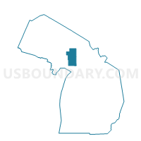
Voting Districts not defined, Schoolcraft County, Michigan
About
Outline

Summary
| Unique Area Identifier | 599556 |
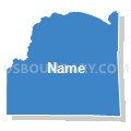
| Name | Voting Districts not defined |
| County | Schoolcraft County |
| State | Michigan |
| Area (square miles) | 662.11 |
| Land Area (square miles) | 0.00 |
| Water Area (square miles) | 662.11 |
| % of Land Area | 0.00 |
| % of Water Area | 100.00 |
| Latitude of the Internal Point | 45.75579730 |
| Longtitude of the Internal Point | -86.13590490 |
Maps


Graphs
Select a template below for downloading or customizing gragh for Voting Districts not defined, Schoolcraft County, Michigan


Neighbors
Neighoring Voting District (by Name) Neighboring Voting District on the Map
- Voting District 0413140000001, Delta County, MI
- Voting District 0975764000001, Mackinac County, MI
- Voting District 1532296000001, Schoolcraft County, MI
- Voting District 1535076000001, Schoolcraft County, MI
- Voting District 1535076000003, Schoolcraft County, MI
- Voting District 1535076000004, Schoolcraft County, MI
- Voting District 1535078000001, Schoolcraft County, MI
- Voting District 1535606000001, Schoolcraft County, MI
- Voting District 1537958000001, Schoolcraft County, MI
- Voting Districts not defined, Mackinac County, MI
- Voting Districts not defined, Leelanau County, MI
- Voting Districts not defined, Charlevoix County, MI
- Voting Districts not defined, Delta County, MI
Top 10 Neighboring County Subdivision (by Population) Neighboring County Subdivision on the Map
- Manistique city, Schoolcraft County, MI (3,097)
- Manistique township, Schoolcraft County, MI (1,095)
- Thompson township, Schoolcraft County, MI (795)
- Garden township, Delta County, MI (750)
- Doyle township, Schoolcraft County, MI (624)
- Newton township, Mackinac County, MI (427)
- St. James township, Charlevoix County, MI (365)
- Mueller township, Schoolcraft County, MI (234)
- County subdivisions not defined, Schoolcraft County, MI (0)
- County subdivisions not defined, Mackinac County, MI (0)
Top 10 Neighboring Place (by Population) Neighboring Place on the Map
Top 10 Neighboring Unified School District (by Population) Neighboring Unified School District on the Map
- Manistique Area Schools, MI (7,611)
- Big Bay de Noc School District, MI (2,260)
- Northport Public School District, MI (2,000)
- Engadine Consolidated Schools, MI (1,955)
- Beaver Island Community School, MI (657)
Top 10 Neighboring State Legislative District Lower Chamber (by Population) Neighboring State Legislative District Lower Chamber on the Map
- State House District 105, MI (95,524)
- State House District 101, MI (92,671)
- State House District 109, MI (90,978)
- State House District 108, MI (87,266)
- State House District 107, MI (86,648)
Top 10 Neighboring State Legislative District Upper Chamber (by Population) Neighboring State Legislative District Upper Chamber on the Map
- State Senate District 35, MI (261,943)
- State Senate District 38, MI (261,728)
- State Senate District 37, MI (258,370)
Top 10 Neighboring 111th Congressional District (by Population) Neighboring 111th Congressional District on the Map
Top 10 Neighboring Census Tract (by Population) Neighboring Census Tract on the Map
- Census Tract 3, Schoolcraft County, MI (3,321)
- Census Tract 1, Schoolcraft County, MI (2,611)
- Census Tract 2, Schoolcraft County, MI (2,553)
- Census Tract 9503, Mackinac County, MI (2,021)
- Census Tract 9701, Delta County, MI (1,631)
- Census Tract 5, Charlevoix County, MI (657)
- Census Tract 9900, Schoolcraft County, MI (0)
- Census Tract 9901, Delta County, MI (0)
- Census Tract 9900, Leelanau County, MI (0)
- Census Tract 9900, Mackinac County, MI (0)